New publication on mapping of retrogressive thaw slumps in the Arctic.
This publication in IEEE Journal of Selected Topics in Applied Earth Observations and Remote Sensing (JSTARS) presents a new method for the detection and mapping of so called retrogressive thaw slumps applied on two areas in Northern Canada.
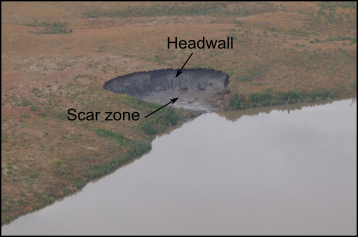
Retrogressive thaw slumps (RTS) arise in thawing permafrost areas and play an important role in the permafrost-carbon feedback that can greatly accelerate global warming. The method is based on measuring the volumetric change by using elevation models generated from TanDEM-X radar observation and is, in contrary to previous work, also applicable at high latitude, where mapping by optical satellites is difficult. This work represents an important step towards investigate and quantify the importance of these features on a pan-arctic scale.
P. Bernhard, S. Zwieback, S. Leinss and I. Hajnsek, "external pageMapping Retrogressive Thaw Slumps Using Single-Pass TanDEM-X Observations," in IEEE Journal of Selected Topics in Applied Earth Observations and Remote Sensing, vol. 13, pp. 3263-3280, 2020, doi: 10.1109/JSTARS.2020.3000648