Master Thesis
At the Earth Observation and Remote Sensing group, we offer various topics for a master thesis. Interested students should inquire at for more information. For open master topics, please look at the relevant page.
General guidelines can be found here, while more information regarding citation etiquette can be found here.
Examples of recently-completed projects are listed below. A complete list is located at the bottom of this page.
Revealing the Recent Height Changes of the Great Altesch Glacier Using TanDEM-X DEM Series
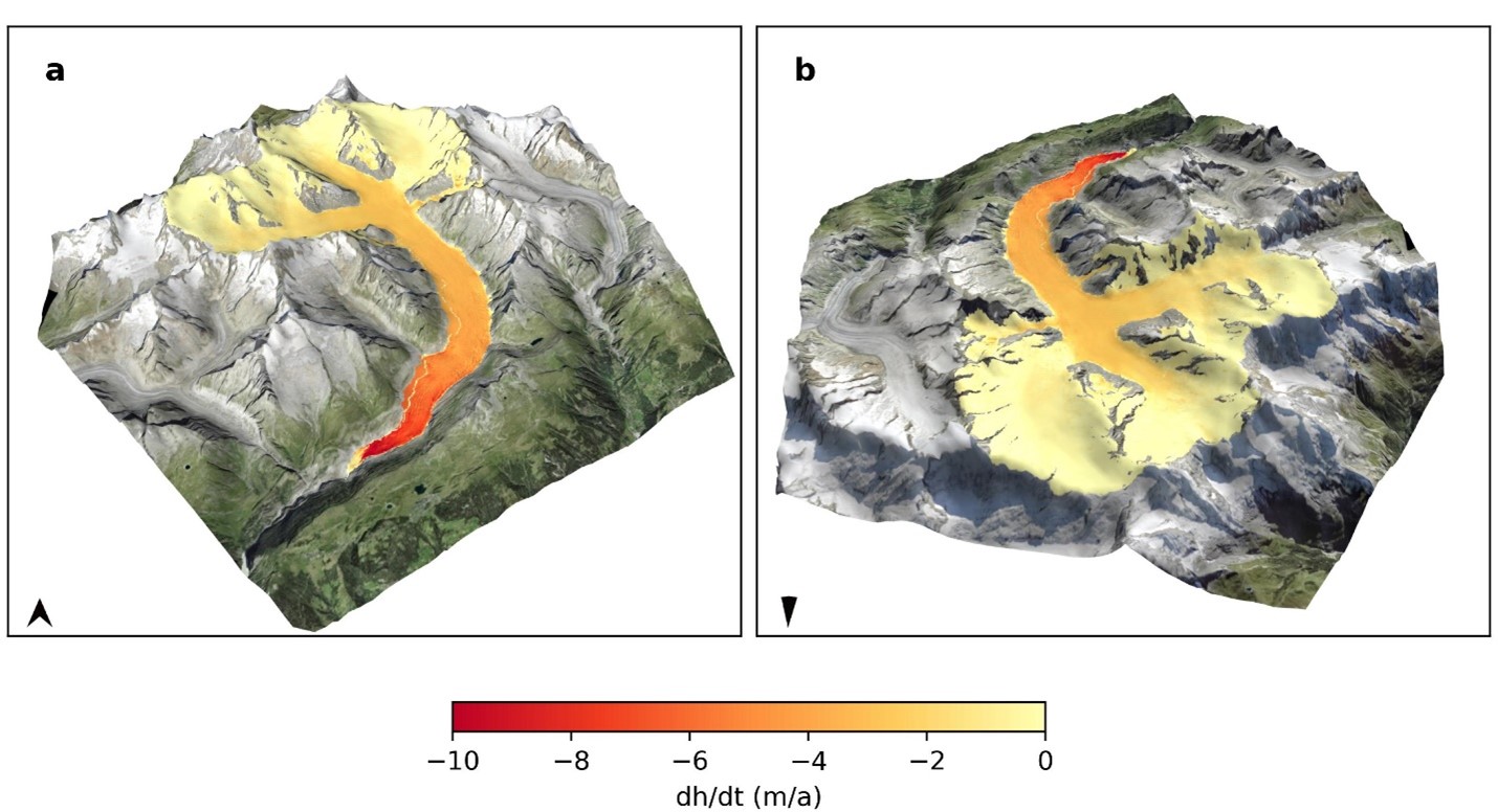
Student: Pierre-Louis Vlieghe
Supervisor: Prof. Dr. Irena Hajnsek,
Shiyi Li
Time period: 2023
Monitoring glacier mass balance is essential for understanding glacier-climate interactions
and predicting water resources management. As the largest glacier in the Alps, the Great
Aletsch Glacier plays a significent role in understanding the dynamics of glacier mass change in this region. The TanDEM-X satellite mission has selected the Great Aletsch Glacier as a super-testsite and has collected abundant single-pass bistatic Synthtetic Aperture Radar (SAR) data over the glacier since 2011.
In this project, leveraging the TanDEM-X data, we generated 124 digital elevation models (DEMs) from the Coregistered Single-look Slant Range Complex (CoSSC) data product, calculated glacier elevation changes between 2011 and 2022, and quantified the temporal dynamics of the mass balance of the Great Aletsch Glacier.Our results revealed a consistent glacier-wide height loss of 1 meter per year on average between 2011 and 2022, corresponding to a cumulative volumetric ice loss of 79×106 cubic meter per year and mass loss of 68 Mt per year (assuming a mean ice density of 850 kg/m3. Notably, the Konkordiaplatz region, situated at elevations between 2600 and 2800 meters, exhibited an average elevation loss of 2.3 m a−1, whereas the Glacier tongue region, ranging in elevation between 1900 and 2100 meters, witnessed an average elevation loss of 5.2 m a−1.
Our results have provided valuable insights into the dynamic changes of the Great Aletsch Glacier by analyzing the abundant TanDEM-X data. The detailed spatiotemporal of our work advanced our understanding of glacier recession in the Alps under the climate change.

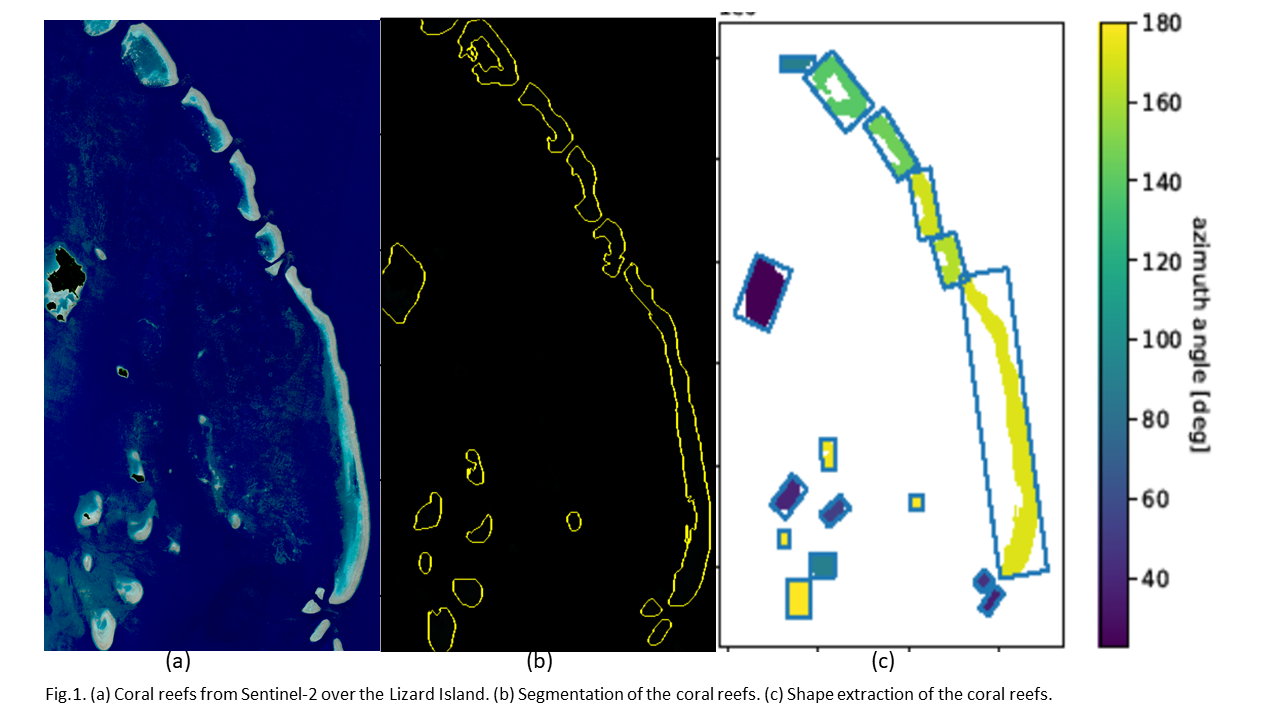
Coral Reef Shapes and Benthic Mapping Capabilities of Sentinel-2 Bands and Spectral Indices
Student: Giulia Zobrist
Supervisors:
Prof. Irena Hajnsek
Dr. Lanqing Huang
Time period: 2022
Coral reefs are marine underwater ecosystems present in most of the tropical and shallow ocean water on the globe. Due to anthropogenic intervention and the consequent rise of ocean temperature the coral reefs have been experiencing drastic changes in the last years. Monitoring these changes is imperative not only for biodiversity purposes but also for the social impact on the coastal communities. Remote sensing (RS) offers great possibilities to monitor coral reefs on a global scale. This Master’s thesis explores the applications of remote sensing for coral reef studies and presents a pipeline for studying coral reef shapes and spectral features. Consecutively, a machine learning framework was applied for substrate classification. The study concludes that the most important Sentinel-2 bands for classifying underwater reef substrates are bands 1 to 5 and that the spectral water indices derived from Sentinel-2 bands are effective to separate the substrate rock from the others. It also concludes that there are some visible trends in the shape of coral reef regionally. Finally, this study provides a machine learning framework for benthic classification whose F1 score is higher than 60%.
Full list of MSc Theses
2023
Pierre-Louis Vlieghe: Revealing the Recent Height Changes of the Great Altesch Glacier Using TanDEM-X DEM Series
2022
Giulia Zobrist: Coral Reef Shapes and Benthic Mapping Capabilities of Sentinel-2 Bands and Spectral Indices
2021
Clotilde Marmy: Exploration of methodologies for landslide susceptibility mapping in Valais
Henry Holsten: Application of Sentinel-1 data to quantify Arctic Coastal Retreat
Xiaochen Zheng: Rare Wildlife Recognition with Self-Supervised Representation Learning
2020
Cédric Tompkin: The Role of Local Resolution Weighting in Automatic Avalanche Mapping with Sentinel-1
2018
Simon Frasch: Parallelized Time-Domain Synthetic Aperture Radar Imaging on GPGPUs
Wicki Raphael: Detection feasibility of snow avalanches in TerraSAR-X datasets for rapid mapping
2016
Round, Vanessa: Surge dynamics and lake outburst of Kyagar Glacier, Karakoram (Co-Supervision)
Liao, Juanwei: Assessment of the Ground Phase Line-fit Estimation Procedure over Agriculture from Polarimetric Interferometric SAR Data
Jing, Huo: The Application of Remote Sensing in PM10 Monitoring in Switzerland (Co-Supervision)
2014
Weber, Melchior: Observing Seasonal Flooding in the Kafue-Flats (Zambia) with Tandem-X Data
2012
Chesnokova, Olga: Analysis on the Relation between Statistical Similarity Measures and Agricultural Parameters: A Case Study